
In the foreword of his renowned work Risk Society (1986), sociologist Ulrich Beck declared that the fear induced by technology would create a “modern Middle Age of danger”, in which the nuclear risk would render all protection zones obsolete, as no one would be able to escape ; there would be no geographical or social protection. [1]
And yet it seems clear that areas close to nuclear installations are more exposed to the risk of an accident, and that different power stations do not present exactly the same types and levels of vulnerability. A nuclear installation forms part of a demographic and economic fabric, a landscape, a territory, and networks of varying density. The risk, although potentially universal (the starting point for Beck’s argument), is nonetheless localised within a given space and unevenly distributed ; from one site to another, the risks and stakes are not the same.
Other authors have subsequently addressed the issue of the perception of nuclear risk by the surrounding population, seeking to take into consideration “social rationality” in order to manage potential accidents more effectively. We might cite, for example, the article by Marc Poumadère (2009) entitled “Les accidents à ma porte. Information des populations et prévenance des risques” (“Accidents on my doorstep. Informing local populations and preventing risks”) ; here, the author suggests that efforts in recent decades have focused on the culture of risk (primarily technical risks, followed by organisational and human risks), at the expense of keeping populations informed and reducing vulnerabilities through a behavioural approach. In parallel, the French doctrine regarding accident management [2] has to reconcile scientific recommendations, the population’s expectations, input from consultation exercises, and political factors.
As a complement to these philosophical and sociological approaches to nuclear risk, a new discipline – the economics of security – seeks to identify the key components of the cost of an accident, according to the severity of the accidents studied. This approach can be a valuable decision-making tool when it comes to assessing different security improvements, different plant fleet management choices (reactor life extension) and different post-accident management options (decontamination, aid distribution, etc.).
This article presents factual, geographical and economic elements, highlighting the variation in vulnerability of different territories in terms of the risk of nuclear accident. The analysis of population and land-use data for the areas surrounding French nuclear power plants is an essential part of the economic analysis of the nuclear risks, in particular for calculating the costs generated in territories affected by an accident.
The surrounding population
An initial indicator of the vulnerability of a nuclear energy production site is the size and density of the surrounding population. Many components of the total cost of an accident – ranging from healthcare costs to crisis management costs to the costs associated with a potential loss of contaminated territories in the most serious cases (definitive exclusion zones, rehousing, cessation of activity) – correlate strongly with the density of the population concerned. Here, population density has been calculated for circles of increasing radius around nuclear sites, [3] which should give an idea of how significantly the cost of an accident can vary from one site to another.
At this stage, an important methodological detail must be pointed out : geographical distance is not a perfect indicator of exposure to risk, which actually depends on many other factors, such as topography, prevailing winds and precipitation levels. This means that a town located in a rainy region 80 km downwind of a nuclear site will be more exposed than a town located only 30 km from the same site but which is protected by hills or the prevailing winds. If, during the discharge of fallout, the wind does not change direction, certain contamination profiles may extend as far as 100 km on one side of the accident site, while the other side could be completely unaffected. However, as it is impossible to know exactly how the weather and fallout behaviour will evolve when an accident occurs, it may be necessary to evacuate a circular area in its entirety as a matter of urgency, as was the case in Chernobyl and Fukushima.
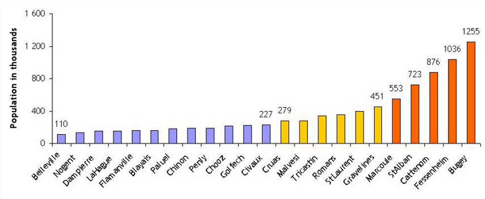
For two thirds of French power stations, there are fewer than 15,000 inhabitants within a 5 km radius. The seven remaining sites are Cruas, Saint-Alban, Tricastin, Gravelines, Chinon, Saint-Laurent and Cattenom. The last of these (located in Lorraine in eastern France, close to the border with Luxembourg) is surrounded by over 60,000 inhabitants within a 5 km radius. At a distance of 10 km, Gravelines is the most populated site, with some 135,000 inhabitants, including much of the Dunkirk urban area.
Similarly, the population within a 30 km radius (see figure 1) is relatively low for half of France’s nuclear sites (with fewer than 250,000 inhabitants). However, four sites have more than 500,000 inhabitants within 30 km, including some major urban areas : Bugey (Lyon is around 30 km away), Fessenheim (Freiburg im Breisgau is 20 km away ; Mulhouse is 25 km away), Cattenom (Thionville and Luxembourg are respectively 10 km and 22 km away) and Saint-Alban (close to a number of towns in the Rhône Valley).
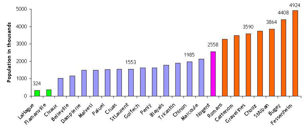
At an even greater distance (see figure 2), Flamanville (together with the nearby La Hague reprocessing plant) stands out as having a much lower surrounding population than the other sites. Seven sites, on the other hand, are in densely populated areas : Nogent, Fessenheim, Chooz, Gravelines, Bugey, Saint-Alban and Cattenom. Between these two groups lie 11 sites whose population within 80 km varies between one and two million.
Let us hope that recent events will impel public authorities to decide on the preparations that would be necessary for a hypothetical mass evacuation, but which currently seem to be lacking. Despite constant advances in the design of emergency plans, specific plans for interventions around nuclear sites cover an intervention distance of only 10 km. During an account of the evacuation of the small town of Vimy in the Pas-de-Calais département of northern France in 2001, in a non-nuclear context, [4] Rémy Pautrat, the prefect of the Nord–Pas-de-Calais region at the time, declared that the evacuation of 150,000 people was “impossible in so little time [one week] and in appropriate conditions”. And yet the majority of nuclear sites exceed this population level – often significantly so – within a 30 km radius.
Land use and economic activity
An alternative, complementary approach for measuring the variability of costs associated with a hypothetical contamination of territories surrounding nuclear sites involves studying land use within, for example, a 30 km radius.
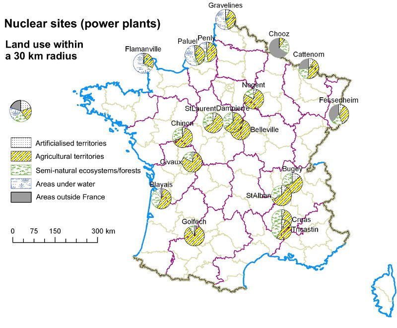
The results, presented in diagrammatic form in figure 3, highlight considerable diversity :
- four “maritime” sites – Gravelines, Penly, Paluel and Flamanville – where around half the study area is covered by bodies of water ;
- heavily urbanised sites (where 9–15% of the territory is built up), which, unsurprisingly, include the four sites with the highest surrounding populations : Fessenheim, Bugey, Cattenom and Saint-Alban (as well as Gravelines if maritime zones are ignored) ;
- predominantly agricultural sites (where over 60% of the territory is dedicated to farming) : Golfech, Civaux, Nogent, Belleville and Chinon ; Penly, Paluel and Flamanville, excluding maritime zones ; and Dampierre and Saint-Laurent, where a more appropriate term would be “agroforestry” sites ;
- two sites dominated by forestry (over 33% of the territories concerned) : Chooz and Cruas.
Certain sites could also lead to contamination beyond France’s borders in the event of an accident (e.g. Chooz, Fessenheim, Cattenom, Gravelines, Bugey).
The considerable economic vulnerability of many farms, the strong attachment of inhabitants to their land in rural areas and a way of life that involves much outdoor activity would mean that farmers would be the first to be exposed, economically and radiologically, in the event of an accident. Added to this is the fact that a certain proportion of agricultural activities would be very difficult, if not impossible, to transfer elsewhere (much more difficult than service-sector activities, for instance), in particular aspects such as protected designations of origin and mountain farming. The clearest example is no doubt that of the “grand cru” wines of the Médoc region, close to the Blayais power plant : how could Pauillac and the surrounding villages be relocated in order to continue production of Château Lafite or Château Margaux ?
In built-up areas, aside from the question of evacuation, there is another issue that clearly illustrates the management difficulties that can arise in the event of an accident : manufacturing and service-sector activities. For example, how would the authorities react if the port of Dunkirk – the third-largest port in France, the country’s biggest rail port, the most important French port for coal, copper and containerised fruit, and soon to be the location of a €1.3 billion methane terminal – located just 10 km from Gravelines, were to be contaminated ? Whole sectors of industry would be sustainably affected, and all their logistics arrangements would have to be completely redeployed. Similarly, the port of Cherbourg, with its strategic shipbuilding activities, Lyon Saint-Exupéry airport (the fourth-largest in France) and the industrial sites of the Rhône Valley are all potentially exposed.
Following the Fukushima accident, the concentration of certain manufacturing activities in the vicinity (spare parts for computers and cars, chemicals, etc.) led to shortages and operational problems throughout the world and across entire industries whose activities depended on the output of just a few factories. An accident in France could also result in extensive disruption to economic flows. Furthermore, although the consequences of an accident on agricultural sectors have been studied and taken into consideration, the same cannot be said for the post-accident redeployment of industrial and commercial activities, [5] and the attendant insolvencies, relocations and chain of disruptions.
Conclusion
Demographic and land-use data, when analysed and mapped appropriately, can be used to construct a “territorialised” vision of risk – taking account of local socio-economic parameters – and thus obtain a better understanding of the complexity and variability of the consequences of a potential accident.
The sets of data presented in this article are, on their own, far from sufficient for a complete evaluation of the nuclear risk in the vicinity of a site. However, such data can be useful when considered in conjunction with accident probability data, radioactive fallout scenarios using realistic meteorological conditions (in order to avoid simplistic reasoning based on concentric circular zones), taking account of risk aversion on the part of the population and decision-makers. Such evaluations of the complete cost of a nuclear accident are the subject of detailed studies at the laboratory for the economic analysis of nuclear risks at the IRSN (French Institute of Radiation Protection and Nuclear Safety).
Bibliography
- ASN [6]. 2008. “La gestion post-accidentelle d’un accident nucléaire”, Contrôle, no. 180, July.
- Beck, Ulrich. 1986. La société du risque. Sur la voie d’une autre modernité, Paris : Champs Essais.
- Butler, Declan. 2011. “Reactors, residents and risk”, Nature online, 21 April.
- IRSN [7]. 2011. “Les leçons de Tchernobyl”, web dossier.
- IRSN. 2011. “Situation au Japon”, web dossier, 13 April.
- Risques, les cahiers de l’assurance. 2011. “Peut-on gérer le risque nucléaire ?”, dossier, no. 86, June.
- Poumadère Marc. 2009. “Les accidents à ma porte. Information des populations et prévenance des risques” in Specht, Maryline and Planchette, Guy (dir.). 2009. Le défi des organisations face aux risques, Paris : Economica.


