
The community plan for the neighborhood of St Johns in the north of Portland, Oregon, prioritizes both neighborhood character/“small-town feel” and a move away from autocentric design, towards walkability and improved pedestrian safety. On the surface, these goals seem compatible, but what happens when a proposed street realignment addresses one, but threatens another ? This was the crux of the conflict, when two contingents of this tight-knit community waged war over the fate of a small piece of public land known as Ivy Island.
For supporters, the street realignment was a community benefit that provided much-needed pedestrian safety upgrades. To the opposition, it destroyed a character-defining feature of the neighborhood, and gave public land to a private developer, setting a dangerous precedent. The erasure of this symbolic piece of public land became a proxy for neighborhood change and gentrification during a time of major change citywide, and illuminates anxieties about loss of local control and identity.
Small town in a big city
St Johns, a neighborhood of about 12,000 residents at the edge of Portland, was an independent municipality until 1915. A sense of regional pride and working-class character is intrinsic to its identity, as well as a tradition of grassroots advocacy. St Johns’ relationship with the City of Portland has long been fraught with conflict, from serving as the location of the city dump for over 50 years to community efforts to reroute interstate truck traffic from the center of town. This has resulted in a wariness of city bureaucracy.
The St Johns/Lombard Plan (SJLP), created through a community engagement process and adopted by the city in 2004, guides development and investment in the neighborhood. It is solely advisory and interpretive in nature. In the late 1990s, St Johns’ business corridor was struggling, and thus the plan prioritizes economic development, and articulates a vision for a vibrant downtown with more density and housing. It does not anticipate gentrification, and accordingly does not include a displacement mitigation strategy.
Ivy Island was located at the eastern entrance to St Johns’ downtown area, and was the primary element of the gateway to the commercial corridor. It featured a “Welcome to St Johns” sign and marquee, nine mature trees, and, in recent years, had been landscaped by community volunteers. The battle over Ivy Island began in response to a proposed street realignment that entailed eliminating the island and creating a standard square corner (see Figure 2), as part of a mixed-use development project. In return for incorporating these proposed changes, developer Farid Bolouri would receive land in the public right-of-way to build on, including part of Ivy Island. The small public corner plaza built to replace the island would be a privately owned public space (POPS), and would likely include seating for adjacent businesses, making it different in use and perceived accessibility (it might appear to be part of the apartment complex’s space).
Opposition to the street realignment unfolded in several dimensions. The physical impacts of the street realignment were of primary concern for many, and included the loss of a coherent and familiar neighborhood gateway ; loss of tree canopy ; an obscured sight line into the commercial district ; and temporary road closures, which would impact local businesses. Some were also opposed on an ideological level. The relinquishment of public land to a private developer symbolized a loss of local control, and catalyzed community anxiety over neighborhood change and loss of local character and identity. This anxiety was also tied to apprehension about the kind of cultural and socioeconomic neighborhood change this upscale development represents for the traditionally working-class neighborhood. Both sides were concerned about these aspects, but differed in their response and in what they felt was within their power to control.
There was also disagreement over the correct interpretation of the SJLP. Save Ivy Island activists felt this proposal contradicted the “spirit of the plan” (and some of its finer details), which prioritizes the preservation of local character (Teply 2015). Conversely, leaders within the St Johns Neighborhood Association (SJNA) and others viewed it as a straightforward implementation of the plan’s safety recommendations. There were also concerns that the decision about the street realignment was made behind closed doors, without any opportunity for meaningful community input (Teply 2015), and that the developer’s efforts to engage in a community dialog had not been sufficient. This conflict caused deep rifts between some of St Johns’ most ardent community advocates.
An imperfect union
In early 2014, developer Farid Bolouri and architect Alan Jones applied for a permit for a four-story mixed-use development called The Union at St Johns. The development was to include over 100 units of market-rate housing, and 20,000 square feet (1,860 m²) of ground-floor retail units (Urban Works Real Estate 2017). It was one of the largest and tallest developments in St Johns’ history, but was within what was permitted by the city zoning code.
The team initially proposed a design that brought the building all the way to the edge of the property line, abutting the downtown gateway. The Portland Bureau of Transportation (PBOT) then approached them with a proposal to incorporate a street realignment into the development. In exchange, PBOT offered them public land, with the understanding that part of the corner adjacent to Ivy Island be developed as a public plaza, and the other site remain in the public right-of-way.

Source : City of Portland Bureau of Planning 2004 (p. 36).
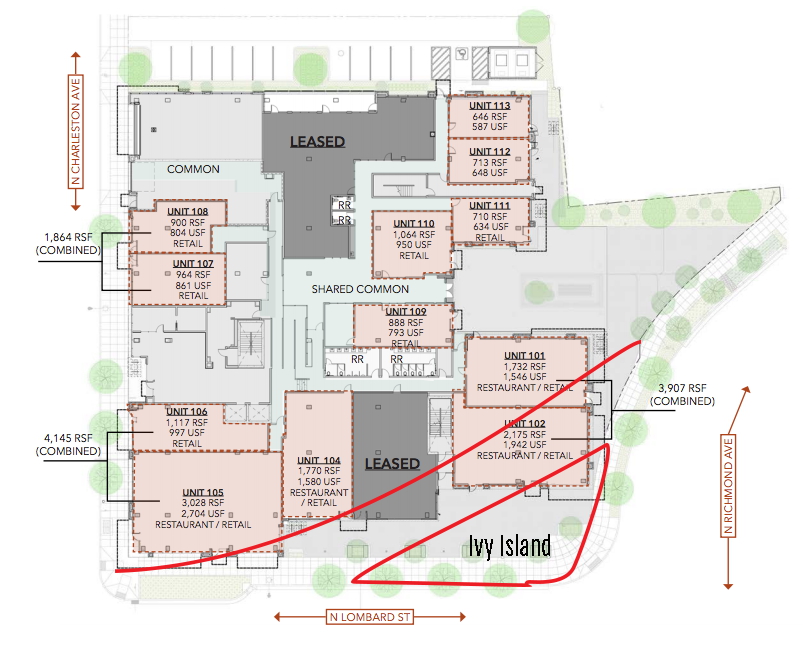
Source : Urban Works Real Estate 2017.
This realignment referenced the “preferred option” out of three proposed in the SJLP (see Figure 1). The intention was for this corner plaza to create a new gateway that would replace Ivy Island, while maintaining roughly the same amount of public space. However, in addition to the public plaza on the corner, the new design also extended the footprint of the building well into what was currently public right-of way, which was a departure from the SJLP’s recommendation. Since it was a project by a private developer, there was no public design input opportunity or process (Lynsky 2017).
The development team held two outreach meetings with the St Johns Center for Opportunity (SJCO) and two with the SJNA in early 2015. Community activist John Teply made his first appearance at a later (July) SJNA meeting, when Jones presented the plans and fielded questions. Teply voiced his concern that the development was not in keeping with St Johns’ small-town feel, and suggested fixing the safety issue by setting the buildings further back from the street and adding traffic-calming measures instead of eliminating the Ivy Island gateway (SJNA 2015a, 2015b, 2015c).
Save Ivy Island
Shortly thereafter, Teply formed Save Ivy Island (SII), and members began canvassing the neighborhood with a petition against the street realignment. They eventually gathered 1,200 signatures (Teply 2015). According to SII, PBOT never engaged the public in discussing alternative solutions to eliminating Ivy Island and squaring the corner. Though the developer did hold public meetings, SII felt they were performative, and that the street realignment in particular was already a “done deal” (Teply 2015). Leaders in the SJNA countered that public meetings had been held, and many now voicing opposition had not been present. Former SJNA vice-chair Shamus Lynsky believed that some people didn’t necessarily understand the petition they were signing, and may have thought it was to stop the entire development (Lynsky 2017).
The situation became increasingly heated, with community activists divided into ideological and pragmatic camps. The SJNA felt that though there was nothing they could do to stop the development, which was allowed per the zoning code, this was a best-case scenario because Ivy Island was an underutilized public space and the intersection would be safer. Lynsky expressed his frustration at what he perceived to be the conflation of saving Ivy Island with opposition to neighborhood change, which overstepped the bounds of what the community could reasonably control. Furthermore, he wondered if the drama resulted in a missed opportunity to leverage the public land giveaway for public design input on the new plaza (Lynsky 2017).
Supporters of the street realignment also argued that it simply followed the SJLP, which called for less autocentric design, increased pedestrian safety, more mixed use along North Lombard Street, and walkability. Although there was a lot of agreement across party lines that a four-story development wasn’t ideal, former SJNA land-use chair Josh Leslie summed up the pragmatic stance in this Facebook post : “Since we’re not always going to get everything we want (or even agree what we as a community do want), I just think it’s important to be strategic about the lines in the sand we draw, so that we’re getting the best results for our time and energy”. [1] Getting a private developer to pay for safety improvements the city could not afford was seen as an obvious benefit.
SII objected to the land giveaway on principle, warning that “once we ‘privatize the commons,’ there will be no getting it back” (Teply 2015). Teply told the St Johns Review that he understood the development would happen either way, but would “like to see Farid Bolouri build only on the land he currently owns” (Patton 2015, p. 1). Because the plaza would be a POPS, the rules governing its use could potentially be different than with a publicly owned space like Ivy Island (Mitchell 1995). SII maintained that other interventions for improving pedestrian safety should have been considered, and that the plan was substantially different from what was proposed in Figure 1. Teply explained that “[t]he SJLP was a good plan and showed us how we could keep the character that we like of St Johns and move forward” (Teply 2017).
In January 2016, the SJNA board voted unanimously to support the street realignment, and in February it was approved by the city council (Council of the City of Portland 2016). The plan had already passed the design review, so there was no opportunity for the city council to weigh in on design aspects. The only modification was to accommodate Commissioner Fritz’s request that an easement be placed on the corner plaza, to ensure it remain publicly accessible in perpetuity. She also voiced concern about how the second plaza bled into private property, and thus might read as such.
Ultimately, both groups shared similar concerns about affordability, scale, parking, neighborhood character, and aesthetic homogeneity that might threaten St Johns’ unique identity. As Teply said, they had vastly more in common than not (Teply 2017). Reflecting on the situation two years later, Lynsky said he understood SII’s position, and commended their hard work, though he still felt that squaring the corner was the right thing to do. The core of the disagreement was over the importance of maintaining the island gateway and its symbolic and material importance. Lynsky said, “It felt like a lot of folks were fed up with all of these expensive apartments and condos coming in, and they wanted to take a stand against that symbolically by opposing the fixing of this intersection” (Lynsky 2017).
While both sides had valid points, PBOT’s conclusion that squaring the corner (and thus giving away the land) was the best and only option evokes Flyvbjerg’s (1991) theories on rationality and power, wherein technical expertise can be used to rationalize decisions that serve powerful interests such as developers and investors. This is not to suggest some kind of nefarious conspiracy, but there are parallels with SII’s claim that PBOT and Bolouri “cherry-picked from the SJLP” (Teply 2015) to achieve their desired result. SII cited examples of how similar safety concerns have been addressed using other methods throughout the city, and proposed alternatives. Ultimately, there was no process through which they could be taken into consideration, as the street realignment had already been approved. In that sense, it’s unclear how much even the SJNA’s opposition would have mattered.

The project was completed in early 2018, and the street was reopened after nearly two years of closure. This image shows the rear plaza, with the site of Ivy Island just out of frame left. Studio apartments for rent start at $1,250.
Photo source : C&R Real Estate 2018.
As Carr et al. (1992) write, “Public spaces often come to symbolize the community and the larger society or culture in which they exist.” (p. 23). Though Ivy Island was not a traditional public space like a plaza, its erasure and replacement with a POPS symbolized an invasion of outside capital and cultural norms to some. In this sense, Ivy Island was “symbolic and imagined” (Watson 2006, p. 20) as much as it existed in the physical realm.
Bibliography
- C&R Real Estate. 2018. The Union at St Johns [website].
- Carr, Stephen ; Francis, Mark ; Rivlin, Leanne G. ; and Stone, Andrew M. 1992. Public Space, Cambridge : Cambridge University Press.
- Flyvbjerg, Bent. 1991. Rationality and Power, Chicago : University of Chicago Press.
- City of Portland Bureau of Planning. 2004. St Johns/Lombard Plan : A Cooperative Planning Effort for the Peninsula, May 26, 2004.
- Council of the City of Portland. 2016. “Official Minutes – Regular Meeting of the Council of the City of Portland”, 10 February.
- Lynsky, Shamus. 2017. [Personal interview], 29 November.
- Mitchell, Don. 1995. “The End of Public Space ? People’s Park, Definitions of the Public, and Democracy”, Annals of the Association of American Geographers, vol. 85, no. 1, March, pp. 108–133.
- Patton, Gayla. 2015. “Ivy Island : keep it or dump it ?”, The St Johns Review, vol. 112, no. 22, 30 October, pp. 1, 4.
- St Johns Neighborhood Association (SNJA). 2015a. “General Meeting of the St Johns Neighborhood Association Minutes”, 9 February.
- SNJA. 2015b. “General Meeting of the St Johns Neighborhood Association Minutes”, 15 April.
- SNJA. 2015c. “General Meeting of the St Johns Neighborhood Association Minutes”, 13 July.
- Teply, John. 2015. Save Ivy Island.
- Teply, John. 2017. [Personal interview], 1 December.
- Urban Works Real Estate. 2017. “The Union at St Johns : New Mixed-Use Development in St Johns”, Urban Works Real Estate [website ; page no longer available].
- Watson, Sophie. 2006. City Publics : The (Dis)Enchantments of Urban Encounters, London/New York : Routledge.


